- Package Name : Tilicho Lake Trek
- Package Duration : 14D/13N
- Package Level: streneous
Trekking staff will arrive at your hotel at 6 am in the morning to pick up then 5 hours driving journey to Besi sahar and Jagat. it is about 60 km driving.we will take prithvi highway to dumre then we will head to Besi sahar and Jagat by jeep.
The trail continues zigzag way across the right side Marsyangdi river view and after crossing again suspension bridge in the Marsyangdi River the trail goes uphill and gradually steep flat and get to Tal. Tal is one of the famous places for valley views and waterfalls. We enter Manang district, the trail continues through barley, rice, potato fields and pine forests past the village of Khotro (1860m). Descend to a forest to a long suspension bridge and very pleasant courtyards of Alpine. Passing through Karte and Nache village, the new trail continues a stone Kani making a formal entrance to Dharapani. Dharapani is one junction way for Manaslu round and also big villages in the Manang valley.
After registering in the ACAP office, gradually climbs over a spur. Walk to Bagarchhap (2160m) through a forest of blue pine, spruce, hemlock, maple, and oak. The trail stays on the south bank of the river, climbing through forests to Danaque (2210m), a valley surrounded by apple orchards. Climb steeply crisscrossing section of the road through rhododendron forest. The trail climbs along the mule track through in and fir forest and then follows the river for a time amongst the higher oak and maple trees. At the entrance to Chame is a long wall with many prayer wheels; the administrative headquarter of the Manang district. There are fine views of Lamjung, Annapurna II/IV (7525m). Stay overnight at guest house.
Climb past Mani walls to a field of buckwheat in tiny village Telekhu (2840m). There are a long, peasant and mostly level walk in forests with some dramatic scenery as you walk through a deep gorge. The pine-scented trail rounds a bend to reveal the first views of dramatic Paungda Danda rock face, a tremendous curve slab of rock. Over a ridge marked by prayer flags and stone cairn, continue the steep ascent to the upper Marsyangdi. The trail follows through the river valley with good views along the way of Pisang peak and Annapurna II at Pisang. Pisang marks the beginning of the region upper portion of the Manang district.
It’s about 6-7 hours trail. From upper Pisang, the high trail enters pine grooves to reveal views of the small turquoise lake. The trail does a dogleg through the charming village, passing with views of painted Mandalas and dragon mouth spouts. Hike through the fields of grazing yak and a wide variety of crops. The trail climbs a steep ridge right side of the Marsyangdi River to get Ngawal (3660m) but it is one of the really great viewing points of the whole Annapurna Ridge and the Marsyangdi river valley view. On the way, we pass pine forests, villages such as Braga and farming terraces. The large Tibetan settlement Manang provides good views of Annapurna II/III/IV, Gangapurna and Tarkekang. Stay at 3570m.
This day you spend the second night in the Manang region to acclimatize to the higher elevations you will encounter towards the Thoroung La. Take advice from Himalayan Rescue Association and observe the spectacular views of the Himalaya nearby. There are fine views of the milky blue glacier lake at the foot of spectacular Gangapurna icefall and traditional stone buildings. You can explore Khangsur Village, Kecho Lake or Milarepa Cave. Stay overnight in camp.
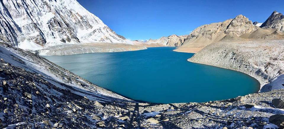
The trail climbs steeply past the Gompa and small chortens, the trail goes through juniper and sea buckthorn bushes. The path is quite covered by small crystals and shrubs can be seen on both sides. Some places along the trail you cross a few streams. You reach a crest (4650m) with prayer flags after the wearying climb and then through a series of zigzags down a scree slope bring you to the Tilicho Base Camp Hotel. From here you can enjoy the closer and panoramic views of Tilicho Mountain and many others. Tilicho Lake is situated at the highest altitude so we set our camp today here at low.
TThe trail to the Tilicho Starts up a side valley then traverses onto a moraine, making a long climb to 4710m. There is an outstanding view of Tarkeghyang, Gangapurna and the Khangsar Kang. Tilicho Lake, the highest lake in the world at (4920m), presents a particularly dramatic spectacle. Sometimes its turquoise water reflects the surrounding peaks but more often its frozen solid. After spending the memorable time at Tilicho Lake, we will trek down to Tilicho base camp via the same way for an overnight stay.
The trail continues to climb out of the Marsyangdi Valley. The trail follows this valley north, passing a Goths as it steadily gains elevation. You have left the large trees below; the vegetation now consists of scrub juniper and alpine grasses. you can keep high and follow a track 400meters or so above Khangsar village passing through the ruins of old Khangsar and follow an unmarked trail which will lead you around and down to cross the river on an old log bridge between Gunsang and Yak Kharka. It’s fun to see large yaks grazing at Yak Kharka. The view of Annapurna III is excellent.
The trail becomes steep immediately after leaving Thorung Phedi, switchbacking up moraines and following rocky ridges as it ascends to the Thorung La pass (5416m). You can see the long Great Barrier ridge, Tibet like region of Manang, as well as the Annapurna, Gangapurna and the heavily glaciated peak of Khatung Kang (6484m). The trail descends crossing meadows steeply down to Muktinath. One of the most important pilgrimage sites for both Hindus and Buddhists. It is also home to many ethnics Tibetans and holy Buddhists.
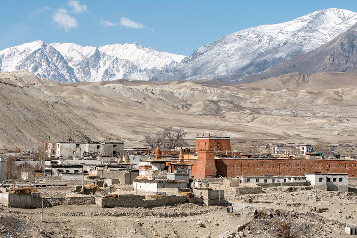
From Muktinath to Jomsom, we see people from Mustang who comes to sell handicrafts to pilgrims. Among them, merchandise is the highly revered mollusk fossil called Shaligram. We will pass some ancient caves and view the impressive white snow-capped mountains. The trail stroll among meadows, streams, poplar and fruit trees, finally we arrive Kagbeni a gateway to Upper Mustang; it has to pose Chortens and ochre-colored Gompa and monastery. After lunch in Kagbeni continues trekking to Jomsom on the windy trail of Kali Gandaki valley, overnight at Jomsom.
Trek to Jomsom via Lubra village (2790m) 6:00hrs
Fly back to Pokhara or by overland back to pokhara
Pokhara Valley Sight Seeing
Fly by Tourist bus to Kathmandu
There is no photos uploaded.


.jfif)
.jfif)